Okay, this is just my understanding of the term, but ‘Easterling’ doesn’t actually mean the Haradrim, who are, as you have pointed out, from south of Gondor. It more accurately describes the people of Khand and Rhun, rather than of Harad (the Haradrim are, in fact, called ‘Southrons’ in the books).
It’s fairly common not to make the distinction though, and to call both the people of Harad and the people of Khand and Rhun ‘Easterlings’ as an umbrella term… probably to delineate those nations that sided together against the West.
And there we have another ‘direction’ grouping – Arnor is North-west, and Erebor is p much directly north (the Iron Hills are more or less in Rhun!), but they are generally lumped in with ‘the West’. The central point of the compass appears to be Gondor, mostly. IDK, it’s probably got something to do with the Numenoreans, It usually does.
Check askmiddlearth‘s post on Rhun and Easterlings here. It includes a map that shows the Orocarni Mountains – which are indeed, to the east. There are some other good maps that show the lie of the continent as well. Here’s some of them:
Haradrim – Southrons, south of Gondor & Mordor
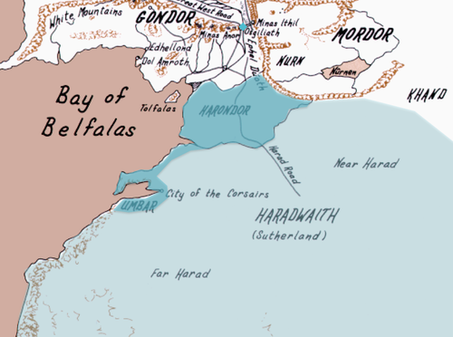
The Variags of Khand – South-East of Mordor
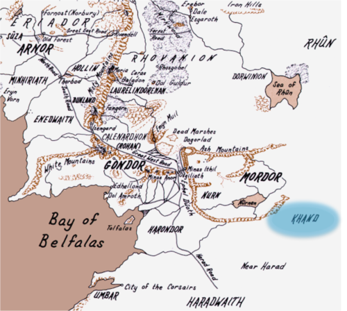
Rhun – Easterlings, east of Rhovanion (incl. Orocarni)

The maps are reproduced from the Appendices of LOTR and from excerpts from Karen Wynn Fonstad’s Atlas of Middle Earth.
